Earth’s Cryosphere, 2016, Vol. XX, No. 1, p. 14-24
FORMATION OF RELIEF IN THE REGIONS OF ICE COMPLEX DEPOSITSDISTRIBUTION: REMOTE SENSING AND GIS STUDIES IN THE KOLYMA LOWLAND TUNDRA
A.A. Veremeeva1, N.V. Glushkova2,3
1Institute of Physicochemical and Biological Problems in Soil Science, RAS,
2, Institutskaya str., Pushchino, Moscow region, 142290, Russia; averemeeva@gmail.com
2Sobolev Institute of Geology and Mineralogy, SB RAS,
3, pr. Akad. Koptyuga, Novosibirsk, 630090, Russia
3 Novosibirsk State University, 2, Pirogova str., Novosibirsk, 630090, Russia; hope@igm.nsc.ru
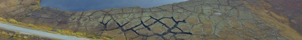
The study of the relief of the Kolyma lowland tundra using remote sensing data and GIS technologies with subsequent construction of a map of Quaternary deposits cover based on Landsat images has been presented. It has been established that the Ice Complex deposits forming positive relief forms (yedomas) occupy 16 % of the Kolyma lowland tundra area. These data are in sharp contrast with earlier estimations of the 1:1 000 000 geological map of Quaternary deposits that shows the Ice Complex deposits cover 40 % of its area. The map of vertical dissection of the relief yielded by this study provides insights into the Ice Complex thickness and extent in the area. The morphological types of the yedoma have been identified, and main regularities of relief evolution in the Holocene summarized. Eight types of land relief have been established and characterized on the basis of the ratios between specific areas occupied by the Iсe Complex deposits and by thermokarst lakes.
Ice Complex, thermokarst, relief, Holocene, satellite images, GIS studies, Kolyma lowland