Earth’s Cryosphere, 2022, Vol. XXV, No. 5, p. 47-59
 GROUND-PENETRATING RADAR SOUNDING OF DEPOSITS WITHIN THE LIMITS OF HIGH-CENTERED POLYGONS IN THE ARCTIC
D.E. Edemskiy1, V.E. Tumskoy2, A.N. Ovsyuchenko3
1Pushkov Institute of Terrestrial Magnetism, Ionosphere and Radio Wave Propagation, RAS, 4 Kaluzhskoe hwy, Troitsk, Moscow, 108840, Russia; deedemsky@gmail.com
2Melnikov Permafrost Institute, SB RAS, Merzlotnaya str. 36, Yakutsk, 677010, Russia
3Schmidt Institute of Physics of the Earth, RAS, B. Gruzinskaya str. 10, bld. 1, Moscow, 123242, Russia
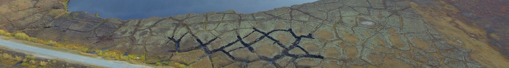
This article analyses the results of Loza-V georadar sounding of the upper part of the permanently frozen ground section in the area of polygonal patterns development. These investigations took place on the eastern coast of the Taymyr Peninsula and on the western coast of Kotelny Island (New Siberian Islands). The polygonal pattern is at the descend stage of development at both sites, so the ground-penetration radar profiles were scanned across the flat and high-centered central parts of the polygons. The results allowed us to determine some peculiarities of ground-penetrating radar profiles for polygons with different types of surfaces, composed mainly of sand-gravel deposits. Typical ground-penetrating radar complexes corresponding to the central parts of the polygons and deposits overlapping thawed ice wedges were identified. The possibility of using the spectrum of waveforms to interpret results was shown, velocities of electromagnetic wave propagation in the studied deposits were determined. Ice wedges and pseudomorphs after them were not reliably identified, but areas of their possible location were.
Ground-penetration radar, polygonal pattern, spectrum of waveforms, hodograph diagram, Taymyr Peninsula, Kotelny Island