Earth’s Cryosphere, 2011, Vol. XV, No. 4, p. 32-35
LANDSCAPE INDICATION OF LOCAL PERMAFROST VARIABILITY (URENGOY TERRITORY, WEST SIBERIA)
N.G. Ukraintseva, D.S. Drozdov, K.A. Popov, A.G. Gravis, G.V. Matyshak*
Institute of Earth’s Cryosphere, Siberian Branch of the Russian Academy of Sciences, PO box 1230, Tyumen, 625000, Russia; ukraintseva@mail.ru
*Lomonosov Moscow State University, Department of Soil Science, 1-12, Leninskie Gory, Moscow, 119992, Russia
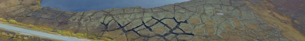
The highly variable properties of frozen ground make engineering-geological mapping in the permafrost zone impossible without cryological monitoring. Integrate monitoring of natural and technogenic landscapes has been run at test sites in southern forest-tundra and southern tundra (area of Urengoy oil-gas-condensate field) by remote sensing along with surface route and instrumental (automated) surveys and GIS mapping. As a result, a set of map models have been obtained that demonstrate obvious relationship between the landscape features and the thicknesses of peat and active layer. The studies have revealed a new indicator of the permafrost thermal state.