Vol. XXVII, No. 1 (January–Februar2023)
Full issue:    EC_1_2023_eng_opt.pdf

CONTENTS


REGIONAL AND HISTORICAL GEOCRYOLOGY

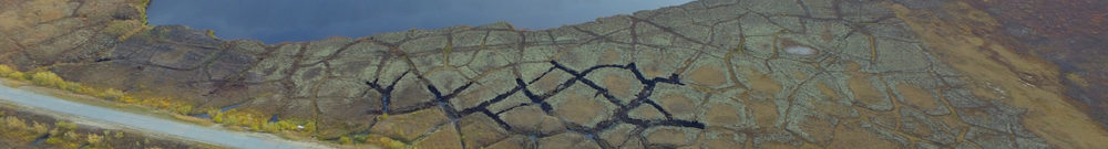
  • Ryzhov Yu.V., Kolomiets V.L., Smirnov M.V. Late Holocene cryogenic deformations in floodplain sediments of river valleys in the Selenga River basin
    Abstract
    The morphology and age of cryogenic deformations (cryoturbations and ground wedges) in the Holocene floodplain sediments of river valleys in the Selenga River basin within the areas of seasonal, discontinuous, sporadic, and isolated permafrost were studied. Late Holocene ground wedges and cryoturbations were identified in the seasonally frozen layer of floodplain sections of the Itantsa, Il’ka, and Orkhon rivers. The time of formation of the cryogenic deformations was determined on the basis of detailed morphological descriptions and dating of low and high floodplain sediments of these rivers. The age of the alluvium with cryoturbation on the low floodplain is less than 2 kyr. Cryogenic deformations on the high floodplain formed in the Late Holocene (the last 4.2 kyr). It was determined that alluvium layers with cryoturbation are underlain by moderately wet to satiated wet loamy sands and loams. Cryogenic deformations are considered a paleoclimatic indicator of the Late Holocene in the Transbaikal region and northern and central Mongolia.


PHYSICAL AND CHEMICAL PROCESSES IN FROZEN GROUND AND ICE

  • Cheverev V.G., Brushkov A.V., Safronov E.V., Kaynov Yu.A., Fedotov A.L. Results of physical modeling of soil freezing
    Abstract
    The article presents the results of physical modeling of soil freezing in laboratory. The samples of silty clay of kaolinite composition were used as model soil. The main characteristics of the component and phase composition of water, as well as the heat and mass transfer and deformation properties of the soil were experimentally determined. During the physical modeling, parameters of the freezing process, differential heaving of frozen and shrinkage of thawed zones, heat and moisture transfer, and pore pressure were monitored. The appearance of segregated ice in the freezing soil, layered axial and horizontal deformation, and the dynamics of density and water content of water-saturated soil samples over time were determined using position markers and time-lapse video.


  • Karavayskiy A.Yu., Lukin Yu.I., Pogoreltsev E.I. Dielectric method for measuring the content of unfrozen water in mineral soil
    Abstract
    The article presents the results of physical modeling of soil freezing in laboratory. The samples of silty clay of kaolinite composition were used as model soil. The main characteristics of the component and phase composition of water, as well as the heat and mass transfer and deformation properties of the soil were experimentally determined. During the physical modeling, parameters of the freezing process, differential heaving of frozen and shrinkage of thawed zones, heat and moisture transfer, and pore pressure were monitored. The appearance of segregated ice in the freezing soil, layered axial and horizontal deformation, and the dynamics of density and water content of water-saturated soil samples over time were determined using position markers and time-lapse video.


SURFACE AND GROUND WATERS IN TERRESTRIAL PERMAFROST REGION

  • Pavlova N.A., Ogonerov V.V., Danzanova M.V., Lebedeva L.S. Hydrogeological conditions in the Lena River floodplain near Yakutsk
    Abstract

    This paper reports on the hydrogeological conditions and groundwater regime in the Lena River floodplain near Yakutsk. The published and archive materials, including field data collected by the authors in 2013–2021, were analyzed. Data from more than 70 boreholes were examined to characterize permafrost and hydrogeological conditions in the area. Data on groundwater level monitoring in the reclaimed area of the floodplain were also used. Over 250 sample analyses were interpreted to characterize the chemical composition of surface and ground waters. The results suggest that suprapermafrost waters in the high floodplain are recharged both by infiltration of river water and by a transit water flow under the river channel hydraulically connected to floodplain taliks. The seasonal and spatial variability of the chemical composition of waters was revealed in the Lena River and in the studied taliks. The surface and ground waters of the Quaternary aquifer on the east bank of the Lena River are characterized by the lowest total dissolved solids (TDS) concentration (0.1–0.3 mg/L) and by the magnesium–calcium chloride–bicarbonate composition. These waters are recharged by fresh water of the supra- and interpermafrost taliks of the Bestyakh terrace and by the riverbed taliks under small rivers. In the vicinity of Yakutsk, TDS concentrations in the Lena River and in the Quaternary aquifer increase to 0.5–1.3 g/L due to high mobility of chloride and sulfate ions migrating with the surface and suprapermafrost runoff from the low terrace, where the city is located.


    SNOW COVER AND GLACIERS

  • Adzhiev A.Kh., Bekkiev M.Yu., Dokukin M.D., Kalov R.Kh., Savernyuk E.A., Shagin S.I. Dynamics of lakes of the Bolshoy Azau glacier on Elbrus
    Abstract
    High rates of degradation of the Bolshoy Azau Glacier on Elbrus make it necessary to assess the development of lakes on the ice-free land and on the glacier itself. For this purpose, aerospace data for the period of 1957–2021, as well as information from visual observations, Internet sources, and tourist photos were analyzed. The existence of 15 lakes with an area of 140–20 250 m2 on the Bolshoy Azau Glacier and the adjacent territory was recorded at various times. The long-term existence of the lake in contact with the glacier on the Echo of the War mountain passage covering with an area of up to 4500 m2 was revealed for the period of 1971–2009. The maximum area (20 250 m2) was detected on a satellite image from June 25, 2009 for a lake on the dead ice part of the median moraine between left and right ice streams of the Bolshoy Azau Glacier. In the hollows on the glacier surface, up to three lakes with a maximum total area of 7860 m2 were observed in different times. Lakes on the Bolshoy Azau Glacier appeared mainly during the snow cover melting, while masses of drifted snow served as dams in the drainage area of hollows. These lakes disappeared after melting of drifted snow dams and/or in the course of drainage through subglacial and underground runoff channels.


METHODS OF CRYOSPHERIC RESEARCH

ADVERTISING

  • Production of equipment for geotechnical monitoring